
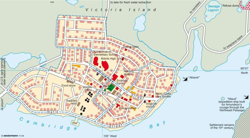
Inuit town Cambridge Bay (Ikaluktutiak), Nunavut Territory (Canada)
The world - Polar regions
978-3-14-100790-9 | Page 170 | Ill. 2
Information
With a land area of more than 200,000 square kilometres, Victoria Island is about three times as big as Bavaria and thus the ninth-largest island in the world. The region belongs to the federal territory of Nunavut in north-eastern Canada, which until the 19th century was inhabited almost entirely by Inuit. In 2007 the entire population of the territory of Nunavut — an area six times the size of Germany — was only some 31,000, of whom 6,000 lived in the largest town, Iqaluit. The hamlet of Cambridge Bay on the southern edge of Victoria Island is home to some 1,500 people, most of whom are Inuit. The native name of the settlement is Iqaluktuttiaq, which means "a good place with many fish".History and Structure of the Settlement
Long before the course of Canada's northern coastline was known, Inuit gathered regularly in the south part of Victoria Island to fish there. The name of Cambridge Bay traces back to the year 1839, when the district was mapped on behalf of the Hudson's Bay Company.
The roots of the permanent settlement go back to the 1920s, when a police and trading post was established. A few years previously, in 1918, Roald Amundsen had launched an expedition through the North-East Passage. Amundsen, the first person to conquer the North-West Passage, and also the first to reach the South Pole, had the ship Maud built for this purpose. The expedition failed, and the Maud was taken over by the Hudson's Bay Company and used as a supply ship for Cambridge Bay, where it foundered in 1930. Today, parts of the hull offer a reminder of this chapter in the opening up of the Arctic.
In the 1940s a lighthouse was built in Cambridge Bay, followed during the Cold War in the 1950s by a radar system — intended to warn of a Soviet attack — which is no longer in operation. These new facilities led to an increase in the number of inhabitants, who had to live in an inhospitable region where average temperatures never rise above 10 °C in summer and the thermometer falls to average levels of below —30 °C in winter.
Today the modest hamlet of Iqaluktuttiaq is less than one kilometre long. To enable so many people to live permanently in isolation from the rest of civilization, the hamlet has numerous facilities in its centre including a kindergarten, a primary school and a secondary school. In addition to a clinic there is also even a small dental surgery. Recreational facilities include a hockey field as well as a swimming pool which is not shown on the map. Iqaluktuttiaq is supplied with energy from oil stored in tanks near the landing place. Water supply and waste water removal is carried out by trucks between 0800 and 1900 hrs.
Tundra vegetation begins immediately beyond the boundary of the built-up area. The cemetery, the garbage tip and an airfield are sited here. There are regular flight connections, mainly to Yellowknife, south of the Great Slave Lake. This makes nature tourism possible, mainly focused on the muskoxen that live in the vicinity.
D. Falk; Ü: J. Attfield
