
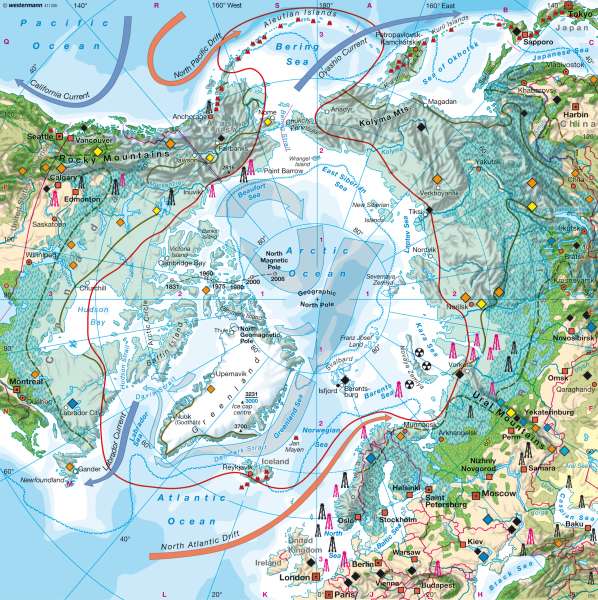
North polar region (Arctic)
The world - Polar regions
978-3-14-100790-9 | Page 170 | Ill. 1
Information
The region around the North Pole includes the 14.3 million square kilometre wide and partly over 5,000 metre deep ocean basin of the North Polar Sea, its variously-shaped islands, and the northern coasts of North America and Eurasia. On account of the light conditions and the phenomenon of the polar day and polar night, the polar zones in the north and south extend to the polar circles. The zone encompassed by the Arctic Circle includes forested regions of northern Scandinavia, while on the other hand it excludes southern Greenland which is covered by inland ice. In the Northern Hemisphere the tree limit (10 °C July isotherm) is also taken to define the boundary. The distribution of mineral resources and large settlements shows the economic significance and the boundaries of the anecumene.Climate and Landscape
The polar regions are the zones in the high latitudes where there is never any summer in the sense that is understood in our moderate latitudes. The changing radiation conditions cause different light seasons. It remains cold or cool also in the summer months. The average annual temperature at the North Pole is minus 18 °C. The characteristic conditions and landscape features of the polar zones, as determined by the cold climate — such as glaciers extending to sea level, sea ice, permanently frozen subsoil (permafrost), tundra, frost debris and ice desert — extend southwards to varying distances on the surrounding continents. In the interior of Greenland, ice has built up to form mountain plateaus over 3,000 metres high, and in some places reaching to below sea level.
Despite this, in many places the Arctic only has limited annual precipitation, often below 500 mm, which mainly falls as snow. This remains for long periods. In a drilling core from Camp Century on the inland ice in north-west Greenland, ice was found that was over 100,000 years old. From the temperature-dependent relationship of the oxygen isotopes O16/O18 in ice drilling cores it is possible to determine the development of the climate. Thus the large ice masses in the polar zones also serve as an "archive" for the Earth's long-term climate development.
Currents and Extent of Ice
Through the wide gate of the North Atlantic, the warm ocean current of the Gulf Stream brings a heat anomaly far into the north. While the average temperature at the 70th parallel is —10.7 °C, in the comparable latitude on the west coast of Norway near Tromsö there is an average annual temperature of +2.9 °C. As a result the seasonal limit of the sea ice is pushed northwards to above Spitzbergen. The cold counter-current of the East Greenland Current carries drift ice far to the south, with a maximum extent of 11 to 15 million square kilometres, as far as the 40° north latitude where icebergs can endanger the shipping lines between Europe and North America.
Most of the east coast of Greenland also remains enclosed by drift ice in summer. On Greenland's west coast, where the largest settlements are situated, the coastal waters and the majority of fjords are ice-free as far as to the north of Thule. A maelstrom of currents in the Beaufort Sea off the coast of the Mackenzie River mouth and Alaska keeps the all-year pack ice cover in drifting movement. Here, as off the northern coast of Siberia, narrow polynias (areas of open water in the sea ice) open up and keep the North-East Passage to the ports of Siberia and the North-West Passage through the tangle of islands in the Canadian Arctic clear. Sea ice conditions change sharply from year to year. The sea ice is normally up to three metres thick and is only compressed in some places into pack ice up to 25 metres thick. With powerful icebreakers and submarines it is possible to sail to the North Pole. Today the changing sea ice conditions in the Arctic are registered by weather satellites. As a consequence of global warming, the minimum extent of the sea ice fell to 4.13 million square kilometres in September 2007, exceeding the previous record minimum from the year 2005. This was not a singular extreme year, but a long-term trend.
Vegetation and Land Use
With average temperatures below 10 °C in the warmest month, the vegetation period in the tundra is too short and too cold for trees to grow. In continental zones, for example in north-west Canada and Siberia, the tree limit is already reached at the 12 °C July isotherm. The continuous and island-like permafrost extends far to the south into the coniferous forest regions. On the coasts of the Beaufort Sea and Siberia the permafrost soil in the area of post-ice age flooding (a rise of some 100 metres) reaches beneath the sea in the continental shelf zone, which is significant for offshore natural gas and oil exploration. Above the permafrost a flat thaw layer — mostly only a few decimetres thick — develops every year, which is of importance for geo-morphological processes and forms (frost patterned ground) as well as with regard to the landscape damage caused by any kind of usage. For this reason all constructions and facilities, whether buildings, roads or pipelines, must be made particularly secure.
Subpolar locations, both on the continents and in the region of the old shield structures and the geologically younger sedimentary lowlands, are especially rich in mineral resources. Therefore many important industrial raw materials such as coal, oil, natural gas, ores and precious metals such as gold and platinum are mined in increasing quantities in the difficult polar or subpolar conditions.
Today more than 4 million people live permanently in the Arctic north of the 60th parallel. It is estimated that some 830,000 of these descend from the original inhabitants of this habitat, including the Inuit, Yakut, Sami and many other peoples in north-eastern Siberia.
V. Hochschild; Ü: J. Attfield
