
January precipitation
Africa - Humid and wet-dry Tropics
978-3-14-100790-9 | Page 157 | Ill. 3
Information
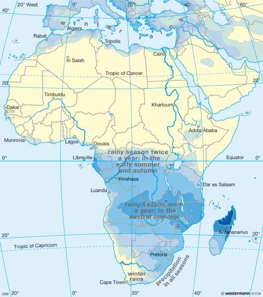
The rhythm of life in Africa is not determined by temperature but by precipitation, and specifically by alternating rainy and dry periods, as the amount and seasonal distribution of precipitation are the crucial ecological factors affecting plant growth.Classification of climate zones
Only the Congo Basin, the region around the mouth of the Niger and eastern Madagascar are exposed to year-round precipitation. With annual precipitation of over 2,000 millimetres, they are classified as tropical regions with permanently humid climates.
Precipitation is controlled by the position and movements of the Innertropical Convergence Zone (ITCZ), in which the north-easterly and south-easterly trade winds converge and produce convective cloud formations. In a phenomenon known as Walker circulation, landward equatorial west winds contribute to increased rainfall. These core regions of year-round precipitation are encircled by areas characterized by a type of equatorial precipitation with an extended dry winter period lasting six months at the most. Annual precipitation in these areas is clearly in excess of 1,000 millimetres.
A precipitation pattern consisting of two arid periods — a short dry period in the summer and a longer one in the winter — is characteristic of the precipitation pattern in the dry savannahs of Africa. Rain falls as the ICTZ moves towards the Tropics of Cancer and Capricorn and when it returns to the Equator. When the advance of the ITCZ toward the Tropics of Cancer and Capricorn (in a slightly delayed reaction to the shifting zenith of the Sun) and its return occur in temporal proximity, the two maximum precipitation periods in subtropical Africa join to form a single summer rainy period (topical summer-humid type).
Areas where annual precipitation is significantly less than 1,000 millimetres are ordinarily arid for more than eight months a year. Fully arid deserts — which are arid up to twelve months per year — with annual precipitation of less than 250 millimetres have formed near the Tropics of Cancer and Capricorn. The core areas of these tropical-subtropical regions lie outside the sphere of influence of the ITCZ and are not exposed to the rainfall associated with the ectropic westerly winds.
Regional climatic phenomena
Aridity is intensified along the west coast of Africa on both sides of the Tropic of Capricorn by the proximity of the cool Benguela Current. Cold water ascending in the Benguela Current cools the air masses above the sea, which are overridden by descending warm, dry masses of air in the area occupied by the Atlantic Subtropical High, resulting in a temperature inversion. Thus the high-level convection that would be needed to generate heavy precipitation is suppressed. Dense fog forms at the inversion boundary, however, and drift as far as 50 kilometres into the interior under the influence of ocean winds. For the flora and fauna of the Namib, which is classified as a coastal desert on the basis of the processes described above, this fog is the most important source of moisture.
In south-eastern Africa, a subtropical high-pressure area over the southern Indian Ocean produces moist air masses nearly year-round which generate substantial rainfall along the east coast of Madagascar as well. This region has a summer-humid eastside climate of the kind that is also found in East Asia.
The Maghreb region in the extreme North and the Cape region in the southernmost part of Africa lie within the sphere of influence of a subtropical winter-rain climate. Due to the shift of the west wind jet stream and the 'wandering cyclones' associated with it toward the Equator, precipitation in these regions is heaviest in the winter and spring. Precipitation exceeds 1,000 millimetres only in a few mountainous areas, however.
East Africa and the Turkana Basin
East Africa represents an exception among African climate zones. Given its position on the planet, its southern part would ordinarily be classified as a permanently wet interior tropic, its northern section as a wet-dry exterior tropic. Actually, however, the Horn of Africa is occupied by semi-arid desert, and precipitation range between 100 and 500 millimetres per year. This dryness is attributable to two primary causes. During the winter months from December to February, these areas lie within the sphere of influence of the north-easterly trade wind, which brings in dry continental air masses from the Arabian Peninsula. During the summer months from July to August, however, the Horn of Africa is exposed to the influence of the monsoon low-pressure cell over the Persian Gulf and India. Consequently, the south-easterly trade wind in the Southern Hemisphere is diverted into the south-westerly monsoon. The coastal region along the Gulf of Aden and especially the Danakil Depression then lie in a leeward position.
Another arid region of East Africa, with precipitation of less than 500 millimetres per year, is the Turkana Basin in northern Kenya, which is only slightly north of the Equator. Here as well, its position leeward of the Ethiopian highlands is one of the causes of aridity, although these lee effects are manifested only under the influence of the north-easterly trade wind during the winter months. During the summer months from June to August, air masses are drawn from the Turkana Depression in the form of valley winds by the vertical rise of air induced by convection over the hot surfaces at the upper elevations of these highlands. Balance is restored over the ocean in the form of descending air masses and the dissolution of cloud formations.
Thus precipitation falls in the tropical arid regions of East Africa only during the brief period in which the ITCZ passes through during seasonal transitions and is concentrated on a few days each year.
A. Siegmund, D. Volz, P. Frankenber; Ü: J. Southard
