
Vegetation coverage in January
Africa - Humid and wet-dry Tropics
978-3-14-100790-9 | Page 156 | Ill. 2
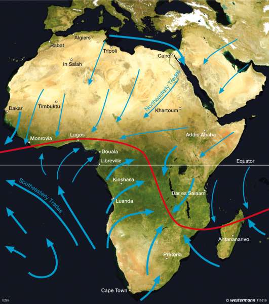
Information
The satellite image shows Africa in January and displays the location of the equatorial low pressure trough and the Intertropical Convergence Zone (ITC). The blue arrows indicate the dominant wind directions.Vegetation zones
Various vegetation belts have developed in Africa according to the amount and distribution of rainfall. On the satellite image of Africa, dark green strips represent the dense vegetation of the more poleward-lying areas near the equator, whereas the bright coloured areas represent areas of poor vegetation growth. The green strips in centre of Africa are only interrupted in the Horn of Africa. While individual green spaces occur in the Atlas Mountains and the Nile Delta in the north of the continent, green areas also occur in the south along the coast of the Indian Ocean and at the Cape Point.
The evergreen lowland forests in Central Africa cover an area with an east-west extent of about 1,100 km and a north-south extent of 800 km. They reach an average height of about 30 m, over which tall trees or "forest giants" can rise up to 40 m in height. The tropical lowland forests are characterised by a considerable number of species. Another characteristic is their developing shoots, flowers and leaf-fall which are uniformly distributed throughout the year, so that the forest gives an "evergreen" impression.
In the north and south the rain forest is surrounded by an approximately 100 km wide semi-evergreen band (also known as seasonal evergreen rain forests).
They are linked by the savannas, which have developed from moist savanna to dry savanna, through to thorn savanna, depending on the number of dry months (three to seven) and the level of average annual rainfall (400—1600 mm).The moist savannas are formed from forest which rise to a height of 18—20 m, alternating with 1.5—2 m high grassland and light woodland.
Further polewards the dry svanna has less than six or seven moist months, with an average annual rainfall of 1,000 mm . The 10—12 m high Miombo rain-green forests of the southern plateau of central Africa belong to the dry savanna.
The thorn savanna follows with 250—500 mm annual rainfall and only 2—4.5 moist months. It is characterised by sparse grass cover and thorn bush.
Even further polewards, semi-desert grasses and small thorny shrubs occur. In addition that, when the very rare rainfall occurs, a moist vegetation germinates from seeds lying on the ground. Scattered grasses and lichens are also found in the adjoining deserts. Sclerophyllous plants are widespread in the northern Mediterranean and southern fringe of Africa.
Differences with the vegetation cover in July
Due to the southern location of the ITC and the ensuing rainy season in the southern half of Africa, the southern savanna areas appear greener than in July. Conversely, in the northern hemisphere, the Sahel is drier than in July (shown in brown in the satellite image).
H. Kiegel; Ü: C. Fleming
