
Giza — Tourism at the pyramids
Africa - Physical
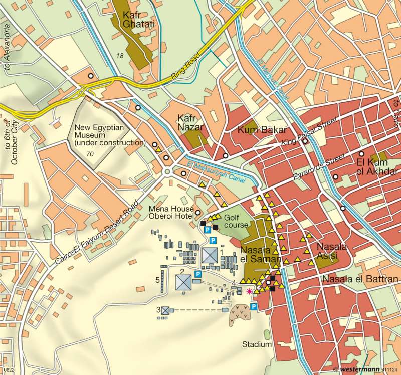
978-3-14-100790-9 | Page 152 | Ill. 2
Information
This section of map shows the Pyramid field of Giza on the prominent edge of the plateau of the western desert, which runs diagonally through the map, while on the right-hand half of the map is the border region of the Nile Valley. The old agricultural land, evidence of which survives as two large canals and a series of rural settlement cores, was only reached in the later years of the extraordinarily dynamic and spatially extensive expansion of the Egyptian metropolis, and almost entirely built over within a very short time. The map focuses attention on the contrast between persistence and change, Pyramids and city edge, and the spatial coexistence of the sublime sites of an ancient high culture and the poor districts of a modern megacity. The current development of Egypt is taking place above all in an area of conflict between continuing urbanization, tourism, the preservation of its cultural heritage, and changes in the countryside. In Giza, the city at the foot of the Pyramids, belonging to the Cairo metropolitan region but remaining politically independent, these processes are superimposed on one another in a multiplicity of ways.The Giza Necropolis
The three great Pyramids shown on the map are part of a Pharaonic City of the Dead from the third millennium B.C., which runs for over 50 kilometres along the edge of the desert and contains more than 80 larger and smaller Pyramids and a large number of tombs and associated structures. The situation of the largest Pyramids (Cheops (137 m high), Chefren (136.5 m high) and Mykerinos (66 m high)) with their associated valley temples and temple causeways is an expression of the belief in the afterlife among the ancient Egyptians, who regarded the deserts as the land of the dead. The Pyramid site is a core component of UNESCO's World Heritage inventory. In the recent past there have been repeated conflicts about the preservation of this area from any kind of building development.
Settlement Processes and Urbanization
The Street of the Pyramids, built in the 19th century, leads straight from Cairo — twelve kilometres distant — through Giza to the luxurious Mena House Hotel and the tourist attractions. This street formed the line that the westward expansion of the city has followed. At the beginning of the 20th century, Giza was still a small town surrounded by extensive irrigation fields and fruit plantations on the western side of the Nile, about halfway between Cairo and the Pyramids. Today 2.5 million people live in Giza, many of them in informal residential districts; and little remains to be seen of the former building fabric. The formerly tranquil country town was long ago fused into the megacity of Cairo. To the west it reaches right up to the area of the Pyramids, and since the 1980s the built-up areas have even extended far into the desert on the rear side of the Giza Plateau. A few kilometres west of the map section is the "City of 6 October", named after the date of the start of the war in 1973, one of the new overspill cities in the vicinity of Cairo.
The population of the Cairo metropolitan region has now reached some 12.5 million people. In the course of the 20th century the urban population has more than doubled as a proportion of the country's total population, from 20 to over 45 percent, while Egypt's population rose in the same period from 10 million to 70 million people. This population growth and the general flight from the land led to an extremely far-reaching urbanization. In the 1950s, 1960s and 1970s — mainly due to massive inward migration from peripheral rural districts — the Cairo-Giza metropolitan region recorded an annual population growth of 4.0 to 4.5 percent. Since then the growth rates in the metropolis have sharply declined, to some 1.4 percent, and are thus below the levels of other types of settlement.
Tourism Development
Tourism is one of Egypt's principal sources of foreign currency, and is therefore of great importance for its economic development. In Giza, for example, there are large numbers of hotels, souvenir shops and riding stables that are aimed at the needs of tourists. However it is also clear from the location of these facilities, which are purely focused on foreign travellers, that the tourist zone is confined within narrow limits and there is hardly any contact between the tourists and Giza's residential neighbourhoods.
D. Müller-Mahn; Ü: J. Attfield
