
Colorado Plateau/Grand Canyon — Land use of a dry region
U.S.A. - National parks
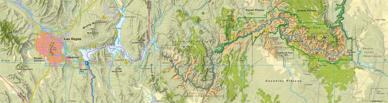
978-3-14-100790-9 | Page 144 | Ill. 5
Information
Today, the Southwest of the U.S.A., with its desert landscapes and the Colorado Plateau, is a popular tourist destination. The Grand Canyon is one of its exceptional attractions. The world's biggest canyon is located in the north of the U.S. state of Arizona. The reason for the magnificent, natural spectacle is the Colorado River, which is impounded by the Hoover Dam behind the Grand Canyon to form Lake Mead. The huge dam's power station provides Las Vegas and other cities in the region with electricity. The "Glitter City" is also a popular centre of tourism and the base for excursions to Death Valley and the Red Rock Canyon.Natural spectacle under protection
As recently as 1869, Major John Wesley Powell explored the interior of the giant canyon on a legendary trip on the Colorado River, whereby he named it the "Grand Canyon". Protected since 1908, the canyon has been part of the National Park of the same name since 1919. In 1979, UNESCO declared it a World Heritage Site. The centre of tourism is the Grand Canyon Village.
Approx. 5 million visitors annually marvel at the rock formations, the colour of which changes from red to brown depending on the light. The Colorado River, which was originally named after its sandstone coloured water, has now "faded" due to the red dust being retained by the dams.
Climate
The climate of the Grand Canyon is very diverse and extreme. In the summer months, the temperature at the South Rim (2100 m) reaches between 10 °C and 25 °C. The North Rim, which is about 300m higher, is opposite the South Rim and is on average about 5 °C cooler. Remnants of the last snow can lie well into June and even in the height of summer, the temperature can drop to near freezing. In summer, the canyon floor can get very hot with the temperature rising to over 40 °C. The annual rainfall in the centre of the canyon is less than 250 mm; at the South Rim it is around 400 mm and at the North Rim up to 700 mm.
Indian Reservations
The Southwest of the U.S.A. is traditional Native American land. As early as 500 AD, the Anasazi inhabited the canyon rim; the remains of numerous settlements have been discovered in the region. The Pueblo cultures experienced their heyday between the 11th and 13th Centuries. In the 15th Century, the nomadic tribes of the Apaches and Navahos migrated to the region from the north. Up until the mid 19th Century, in the course of territorial expansion of the U.S.A., (responsible for the frontier of open, "uncivilised" land being constantly pushed towards California), the Native American people were gradually forced off their ancestral grounds. In the process, not only their freedom and independence was lost, under the sign of the cross and weapons, many lives were also lost.
Those that survived were placed on reservations under the Indian Appropriation Act of 1851. These were located in dry regions that were initially of little interest to the white settlers. Today, the Indian reservations, a number of which are located around the Grand Canyon National Park, are predominantly self-governed.
U. Kleinelümern; Ü: J. Moar, C. Fleming
