
Hurricane Katrina
The Americas - Climate
978-3-14-100790-9 | Page 127 | Ill. 4
Information
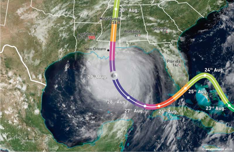
Hurricane Katrina developed from a low-pressure vortex over the Bahamas on 23rd August 2005. On 25th August, at the southern tip of Florida, it reached average wind speeds up to 130 km / h. Over land, the storm weakened and turned slightly towards the southwest. Katrina then moved over the Gulf of Mexico, where it gained further momentum and quickly grew in strength from the 30 °C warm water. On 27th August, the hurricane reached Category 3 with mean wind speeds of up to 185 mph on the Saffir-Simpson Hurricane Scale. Katrina then turned in a more northwest direction. On 28th August, Katrina finally reached the highest category 5 after re-amplification. The mean wind speeds reached up to 280 km / h. On 29th August, the hurricane went further north, turned and hit the southern coast of the United States. Upon reaching New Orleans (Louisiana), Katrina had weakened back to Category 3. Over land, the hurricane rapidly lost energy and evolved over the U.S. state of Mississippi to a tropical storm.Saffir-Simpson Scale
To describe the severity of hurricanes, the five-step Saffir-Simpson scale begins where the Beaufort scale (with 118 km / h) ends. Category 1 includes wind speeds of 118—153 km / h, unsecured houses are damaged. Category 2 refers to wind speeds of up to 177 km / h. Category 3 up to 209 km / h. A Category 4 hurricane of up to 249 km / h completely destroys larger buildings, trees can no longer stand and all coastal areas that are less than 3 m above sea level are flooded. A hurricane of category 5 with its 250 km / h winds is destructive, blowing away houses and bridges and small buildings. Vessels are driven hundreds of yards inland, and up to 16 km inland, areas 5 m below sea-level height are flooded.
A. Siegmund, D. Volz, P. Frankenberg; Ü: Colette Fleming
