
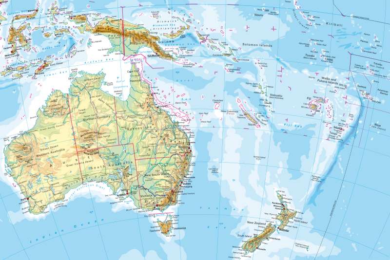
Australia/Oceania — Physical map
Australia/Oceania - Physical map
978-3-14-100790-9 | Page 118 | Ill. 1
Information
Pacific OceanThe largest part of the Pacific Ocean is more than 4,000 metres deep in the narrow, elongated deep-sea trenches and can even achieve up to 11,034 metres (in the Mariana Trench: Witja Deep). The deep-sea trenches mark plate boundaries (eg, Pacific Plate, Philippine Plate). Numerous active volcanoes and frequent earth and seaquakes are an expression of the tectonic activities in shifts (North America), collisions (New Guinea) and diving occurances (Peru-Chile trench) of adjacent plates.
The South Pacific is divided by the east-central ridge marking of the Chilean ridge and the Cocos ridge (Galapagos Islands), the boundaries of the Cocos and Nazca Plates. Between the East Pacific Rise and the Tonga Trench, are a small number of islands. West of the Tonga trench, connects to a highly structured tectonic and turbulent region.
The North Pacific is divided by island ridges into several sub-basins. A central ridge, like in other oceans, does not exist here, thus no new crust is created. The Pacific Ocean is regarded in geological time as a shrinking ocean.
Australia
With a 7.7 million kilometre ² land area, Australia is the smallest continent on earth. Australia is geologically old and very stable, as there is no tectonic activity which could compare with those of Southeast Asia or Oceania. Large areas are occupied by drying, but with different qualities, for example, much less aridity than North Africa. The natural flora and fauna has many endemic species due to isolation.
Oceania
Oceania covers a land area of 1.3 million kilometres ², most of the small islands are scattered over a sea area of 70 million kilometres ². The richness of the Pacific islands is unique compared to other oceans. New Zealand and New Guinea are geologically young, relatively large and partly mountainous islands, passing through the plate boundaries. Respectively, there is an intense tectonic phenomenon. With the numerous small islands, these are mostly atolls (see 185.3) and volcanic islands (see 185.2). Only about one third of these islands are inhabited.
International Dateline
The International Date Line and its course was agreed internationally in 1845. If one crosses it on a Monday and were coming from the west (e.g. on a trip from Asia to America) then the subsequent day would still be a Monday but you gain (apparently one day). Just east of the dateline is Sunday. The time does not change, or changes only an hour, depending on whether the date line coincides at the point of crossing time zones with a border or not (see 37.3). Conversely, if travelling on a Sunday, from America to Asia, you lose (seemingly one day), because west of the dateline is already Monday.
M. Felsch; Ü: Colette Fleming
