
Huang He and Yangtze — Water related problems
China and Japan
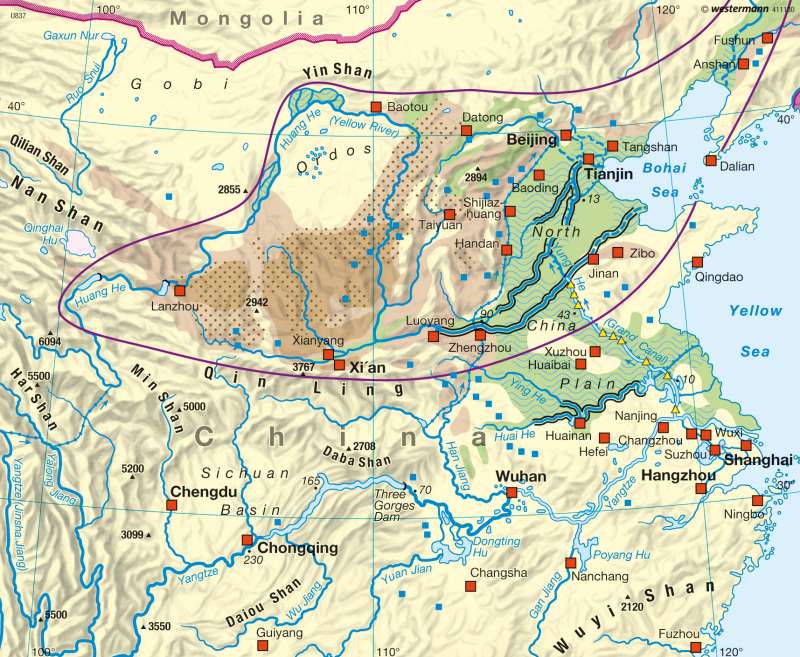
978-3-14-100790-9 | Page 110 | Ill. 1
Information
The Huang He (Yellow River) is China's second-longest river with a length of some 4,850 kilometres. Because of its frequent changes of course in the past it has also been nicknamed "China's Sorrow".River Course and Sediment Load
In its upper reaches the Huang He has the character of a deeply-cut mountain river with large numbers of narrows and rapids. Below Lanzhou it sometimes already attains a width of more than one kilometre; narrow and shallow sections of valley alternate with one another. Some 150 kilometres west of the city of Zhengzhou the Yellow River enters the Great Plain and its bed widens once more. As a result of the reduced speed of flow, the immense load of sediment sinks to the bottom and raises the level of the river bed between its embankments.
As can be seen from the flow diagram in the atlas, during high water periods the sediment load amounts to nearly 30 million tons per day. These huge volumes of silt are carried into the river by erosion processes in the loess regions through which it flows in its middle reaches. Only one-third of the volume of sediment transported by the river reaches the sea.
Conditional on the monsoon climate, the rate of flow and the volumes of sediment reach their maximum in the summer. On account of the increasing removal of water for the needs of irrigation, industry and the population, there are some months nowadays when no water at all reaches the river mouth (see the dotted line of the river below Jinan). A south-to-north transfer of water from the Yangtze River to the Huang He and further north was already proposed by Mao. Shown in the map is the central line of route, starting from the reservoir of the Three Gorges Dam and leading via the Danjiangkou reservoir at the lower edge of the map. The first phase of construction of this long-distance water canal to Peking is to be completed in 2010.
Dyke Building and Flood Protection in the Lower Reaches
For centuries the population in the river's lower reaches has attempted to protect itself by building embankments or dykes. However, vast quantities of silt were deposited between the dykes, with the result that the river bed rose constantly in relation to the surrounding land. In recent decades the rise in the main river bed has been measured at 10 to 20 centimetres annually. In some places the bottom of the river bed lies nearly ten metres above the lowlands on either side of the dykes along its banks. Therefore the river is unable to take in water from tributaries; on the contrary the dykes act as watersheds for rivers that should be serving as tributaries, and the main river also cannot function as the receiving river for the drainage system.
For thousands of years, the flooding of the Huang He has been especially dangerous. According to available records, a total of 1,593 floods were registered before 1949. The river changed its course 26 times.
Since the foundation of the People's Republic of China, enormous efforts have been made to reduce the danger of flooding from the Huang He. Especially since 1955, numerous measures were implemented to regulate the river, in the early phase with the deployment of hundreds of thousands of workers who built hundreds of kilometres of dykes using the simplest of tools. In addition, a large number of flood and retention basins were built. These provide for a more balanced river flow, because the flood basins take in water especially during the peak flow periods. Sediments collect in the basins, and are then carried to the fields or used to strengthen the dykes.
The purpose of the numerous dams is firstly to balance out the annual flow of the river, and secondly for electricity generation.
W. Hassenpflug, W. Taubmann; Ü: J. Attfield
