
Madras (Chennai)
Persian Gulf region
978-3-14-100790-9 | Page 105 | Ill. 6
Information
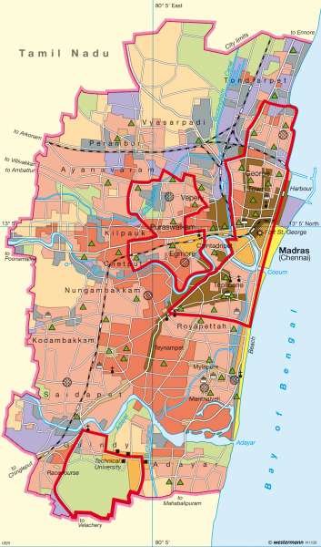
Madras (Chennai), the capital of the South Indian state of Tamil Nadu, with 4.5 million inhabitants (2001), is the fourth-largest city in India after Calcutta, Bombay and New Delhi. The Greater Madras conurbation has a considerably larger population, and the province as a whole has 62 million inhabitants.Thus the map provides an example of one of the giant cities of the Third World, which has expanded to enormous size due to mass migration of the rural population. The problems of Madras's urban settlement and economy are typical of those facing such former colonial cities:
— Stark social contrasts, with extensive slums and villa districts in close proximity;
— A low level of industrialization;
— The predominance of occupations in a heavily bloated "informal sector" (simple services);
— Severe problems of food supply to the urban population (through farmers' markets);
— Problems of urban infrastructure (water supply, electricity, transport, waste disposal).
All these issues confront the urban planners with virtually insoluble problems.
City Origins
From the time of its foundation in 1639 as a colonial trading centre, Madras had already grown to a population of 70,000 by the year 1700. As an administration and government centre of the British East India Company, and (from 1858) of the British colonial power, the city grew to a population of some 500,000 by 1901. By the end of the colonial period (1947), hunger in the countryside and a massive flight from the land had resulted in Madras's further growth to some 1.5 million inhabitants. It was only at this time that the city area was fully built up. Since then, there has been a sharp increase in the density of inner urban development as well as an expansion into the surrounding countryside (partly with planned satellite towns).
Urban Structure
Madras's social and spatial structure is marked by the contrast between extensive slum districts and generously-spaced villa quarters. The slums are mainly found in the flood-endangered lowland areas, along the railway lines or on the edge of industrial districts. Most of the slums came into existence in the 1960s as a result of the (illegal) occupation of empty sites. Today, some 30% of the urban population of Madras live in slums. Viewed in terms of their social position, education, employment and income situation (see chart in atlas), they represent an economically and socially "marginalized" class.
Urban Functions
With regard to Madras's functional structure, predominant in terms of land area is the residential function — although a distinction must be made here between upmarket residential districts with villas, middle-class districts with permanent housing, and slums with temporary huts. The main business district stretches like a ribbon along the most important streets; the only extensive business centre is in the old colonial district of George Town. The numerous farmers' markets, which are mostly housed in covered market complexes, serve to provide the urban population with foodstuffs.
The industrial areas of Madras are mainly situated on the edge of the city and along the railway lines. In the south-west of the city there are planned industrial estates. The public areas are predominantly university sites, indicating the role of Madras as an educational centre. Especially well-known is the extensive Indian Institute of Technology (IIT) in the south of the city, built with German development assistance.
Urban Planning
The most important problems facing urban planners in Madras are in the fields of water supply and living conditions. Plans to supply Madras with drinking water from a large reservoir or from the Godavari River have come to nothing due to political disputes. Provision of drinking water during the dry seasons (approximately from January to August) is currently based on extremely makeshift arrangements, with tanker trucks collecting water from wells and distributing it among the population.
In the framework of slum clearance measures, hut settlements were initially replaced by the construction of low-cost housing blocks. Today, urban planning focuses more on improving conditions in the existing slums, based primarily on self-help by the slum-dwellers themselves.
H.-G. Bohle; Ü: J. Attfield
