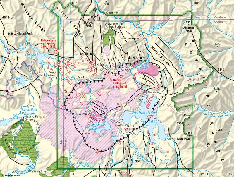
Yellowstone Caldera - Volcanic traces and seismic activity
National parks
978-3-14-100890-6 | Page 188 | Ill. 1

Overview
Large segments of Yellowstone National Park are in the area of the caldera, part of the Yellowstone volcano. Around 640,000 years ago, approximately eight kilometres below ground, a huge caldera magma chamber was formed. It is approximately 60 kilometres long and 40 kilometres wide and ten kilometres thick. Because of these dimensions, the Yellowstone volcano is one of the super-volcanoes and has been active for 17 million years.
Three major eruptions
In the area of Yellowstone National Park, the remains of three overlapping calderas are located, which are attributed to three major eruptions. The largest eruption was Huckleberry Ridge which eruption 2.1 million years ago. In that outbreak, 2,500 square kilometres of volcanic material was ejected creating a caldera, formed by a scale of 80 by 50 kilometres. Relics of that eruption are the surface basalts, which originated from cooled lava. At the Mesa Falls eruption, 1.3 million years ago, only 280 square kilometres of volcanic material was ejected. From this outbreak came the Island Park Caldera. The last major eruption, the Lava Creek eruption 640,000 years ago, created the present-day Yellowstone caldera, with a length of 40 kilometres and a width of 25 kilometres. In that outbreak, 1,000 square kilometres of volcanic material was ejected. From the volcanic ash tuffs emerged rhyolites from the cooled magma. Since the last big eruption, there have been more than 30 volcanic eruptions, which coated the rock stratas with rhyolite. The rhyolites now form an area of 340 square kilometres. Another outpouring of magma formed the Sour Creek dome in the northeast of the caldera and the Mallard Lake dome in the south of the caldera. Today, both domes rise by two to seven centimetres per year.
Continental divide
The main watershed of North America flows through the southwestern part of Yellowstone National Park, its tributaries flow to the Pacific Ocean via the Gulf of Mexico and thus separates the Atlantic Ocean. While the Yellowstone River flows northward and drains through the Missouri and from the Mississippi into the Gulf of Mexico, the Snake River flows south, draining into the Pacific.
Present-day tectonic and seismic activity
Yellowstone National Park is an area of high tectonic activity, which is crossed by numerous faults and repeatedly struck by mostly small earthquakes. In the Lake earthquake of 1959, a magnitude of 7.5 was reached. In 1975, the Norris earthquake reached a magnitude of 6.1. Nearly two thirds of hot springs existing worldwide are located in the Yellowstone area. In total, there are over 10,000 hot springs. The most famous geyser is Old Faithful. Every 60 to 90 minutes, an explosive fountain erupts, throwing up to 32,000 litres of hot water at a height of up to 55 metres. The Steamboat Geyser is the largest active geyser in the world. Its fountain reaches a height of approximately 130 metres. There are several years between the individual eruptions.
Continental divide
The main watershed of North America flows through the southwestern part of Yellowstone National Park, its tributaries flow to the Pacific Ocean via the Gulf of Mexico and thus separates the Atlantic Ocean. While the Yellowstone River flows northward and drains through the Missouri and from the Mississippi into the Gulf of Mexico, the Snake River flows south, draining into the Pacific.


