
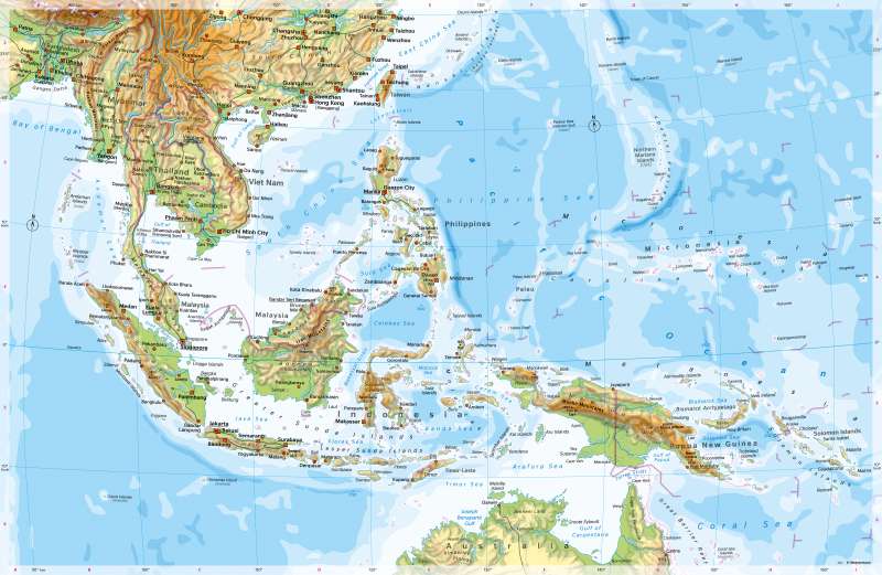
South-East Asia - Physical map
Physical map
978-3-14-100890-6 | Page 134 | Ill. 1
Overview
Southeast Asia consists of numerous, mostly mountainous islands, the Malacca Peninsula and a mainland tip essentially occupied by Thailand, Laos, Cambodia, and Vietnam.
There are clear boundaries to East, Central and South Asia due to mountain barriers and the climatic boundary between the tropics and subtropics.
East of the Himalayas, the high mountain belt, which runs through almost the entire Asian continent, turns south. There, it is divided into individual, partly inaccessible mountain ranges, including the Patkai and Arakan Mountains, the Yünnan-Shan Mountains, and the Annam Mountains along the border between Laos and Vietnam. At over 3000 metres, considerable heights are reached here. Between the mountain ranges are the valleys of large rivers, which become increasingly wider towards the south and open up into coastal plains with river deltas. This is where one of Asia's settlement centres lies, with cities such as Rangoon, Bangkok, Phnom Penh and Ho Chi Minh City. Further south, the mountain ranges run out into the Malacca Peninsula, at the tip of which lies the global city of Singapore. The main shipping route between East Asia and West Asia or Europe runs through the Malacca Strait, which is only 50 kilometres wide at its narrowest point. According to estimates, 20 to 25 percent of the world's trade goods are transported along this route.
Tectonics and island chains
A typical feature is the high intensity of tectonic activity (volcanism, earthquakes) of the geologically young island chains and groups lying at plate boundaries. Borneo forms a relatively stable core in the centre of this region, which belongs to the China Plate. East of the Philippines and southwest of Sumatra and south of Java and the Lesser Sunda Islands, however, deep-sea trenches mark elongated subduction zones where the Philippine Sea Plate or the Indo-Australian Plate dips below the China Plate. Further subduction zones, transform faults and plate collisions can be observed along the Mariana Trench and around New Guinea (see 14.1).
On large islands such as Sumatra or Borneo, there is a contrast between mountain ranges reaching considerable heights and extensive, often swampy plains. With few exceptions, the large urban settlements and agglomerations are located on the coasts or at a short distance from them. A comparison between the widely swampy coastal plains of Borneo and the island of Java with its fertile volcanic soils shows how strongly natural conditions can influence settlement density.
Special features
- The map shows the Vityaz Deep, at 11,034 metres the deepest place in the world's oceans. The highest mountain on the map is Puncak Jaya (4884 m high) on New Guinea.
- Central to Southeast Asia are the island states of Indonesia (with a total of around 17,500 islands) and the Philippines (around 7100 islands).
- In the Pacific are island states such as Micronesia. In an area of 2.6 million square kilometres in the Pacific Ocean - 7 times the size of Germany - there are about 600 islands scattered over a total of 700 sq. km (Berlin: 892 sq. km). Around 100,000 people live on them - one thousandth of the population of Germany.
- Some size comparisons: Java is about the size of Bavaria, Baden-Württemberg, and Hesse together and Sumatra is about 1.3 times the size of Germany. Borneo is 1.4 times the size of France.
- Typical characteristics of river deltas can be worked out using the example of the Mekong Delta. At around 39,000 square kilometres, it is slightly larger than Baden-Württemberg.
- The island of Bali is one of the most popular holiday destinations in the world.
- Some geographical names refer to former German colonies (for example Mount Wilhelm, Lake Bismarck).
- The map shows foreign territories under the sovereignty of the USA (such as Guam).
