
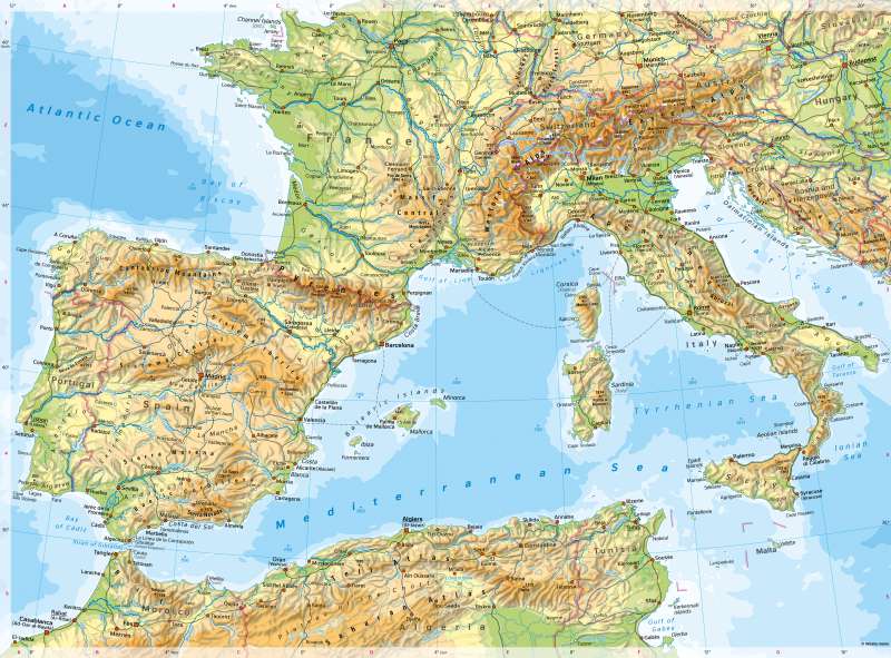
South Western Europe - Physical map
Physical map
978-3-14-100890-6 | Page 102 | Ill. 1
Overview
The south-western Mediterranean region is defined by the contrast between the mountainous landscapes of the Iberian Peninsula and North Africa on the one hand, and the Mediterranean Sea with its islands and narrow coastal fringes on the other.
The oldest mountains originate from the Variscan mountain building event (Massif Central, core of the Iberian Peninsula, Hautes Plaines in northern Algeria). Closely interlocked with them are the younger mountains of the Alpine mountain building event (Pyrenees, Alps, Apennines, Er Rif, Atlas). Between the mountains or embedded in them are, in some places, extensive plains (Po), ditches (Rhône), valleys (Ebro) or wide-stretched basins (Castile). These areas are of particular importance for settlement and economy; the same applies to the coastal fringes.
The Alpine mountain-building phase began at the turn of the Lower Cretaceous to the Upper Cretaceous about 90 million years ago and reached its highest uplift activity about 20 million years ago. It is due to the collision of the African plate with the European plate and is not yet complete in parts of the Mediterranean, such as the Po Valley, the Ionian Sea south of Calabria and the Libyan Sea south of Crete. The active volcanism in southern Italy and the ongoing seismic activity in this area are also considered indications of this. Then, Africa and Europe were connected by mountain ranges. The Mediterranean Sea developed from the former Tethys Sea, which continued to close.
During the Alpine phase, the rest of Europe experienced increased fracture tectonics. Examples are the subsidence of the Upper Rhine and Rhône Graben.
Folding phases
The oldest mountains originate from the Variscan mountain building event (Massif Central, core of the Iberian Peninsula, Hautes Plaines in northern Algeria). Closely interlocked with them are the younger mountains of the Alpine mountain building event (Pyrenees, Alps, Apennines, Er Rif, Atlas). Between the mountains or embedded in them are, in some places, extensive plains (Po), ditches (Rhône), valleys (Ebro) or wide-stretched basins (Castile). These areas are of particular importance for settlement and economy; the same applies to the coastal fringes.
The Alpine mountain-building phase began at the turn of the Lower Cretaceous to the Upper Cretaceous about 90 million years ago and reached its highest uplift activity about 20 million years ago. It is due to the collision of the African plate with the European plate and is not yet complete in parts of the Mediterranean, such as the Po Valley, the Ionian Sea south of Calabria and the Libyan Sea south of Crete. The active volcanism in southern Italy and the ongoing seismic activity in this area are also considered indications of this. Then, Africa and Europe were connected by mountain ranges. The Mediterranean Sea developed from the former Tethys Sea, which continued to close.
During the Alpine phase, the rest of Europe experienced increased fracture tectonics. Examples are the subsidence of the Upper Rhine and Rhône Graben.
Special features
- The highest mountain on the map is Mont Blanc with 4810 metres. The greatest sea depth is reached in the Bay of Biscay with 5858 metres.
- In the Strait of Gibraltar, the distance between the European and the African mainland is the smallest. The strait is only 14 kilometres wide at its narrowest point and is one of the busiest shipping passages in the world.
- In North Africa, wadis, salt pans and periodic or episodic rivers can be identified.
- The Ebro, Rhône, and Po rivers form large delta estuaries.
-Several small states can be identified in the map. Andorra is located in the Pyrenees; the heads of state there are jointly the President of France and the Bishop of Urgell. Monaco, like Liechtenstein, is a principality that does not belong to the EU. San Marino is a republic in customs union with Italy. The head of Vatican City, the smallest state on earth, is the Pope.
- Melilla and Ceuta are Spanish exclaves in North Africa.
- Gibraltar, only 6.5 square kilometres in size, is now a British overseas territory (formerly a Crown Colony) but does not formally belong to Great Britain.
- The Mediterranean region is home to numerous ruined sites; the map shows Pompeii, Selinunte and Carthage, for example.
- On the Iberian Peninsula, numerous dams and canals can be seen. They feed, among other things, the agricultural irrigation systems of the coastal regions on the Mediterranean, but also enable their use for mass tourism.
Settlements and traffic routes
The history of the Mediterranean region is very long. Today, the coasts stand out as preferred settlement areas, particularly in the northern Mediterranean. Like pearls on a string, there are numerous large cities between the Strait of Gibraltar and Naples. Particular points of concentration are the Costa Blanca, the Barcelona metropolitan area, the area around the Rhône delta and the Rome-Naples-Salerno coastal strip. Other focal points of settlement in the northern Mediterranean are the large river valleys and basins of the Iberian Peninsula (for example on the Ebro and the Guadalquivir), the valleys of the Garonne and Rhône, and especially the Po Valley. Comparatively few cities in the mountains or the often very dry landscapes far from the coast in the interior of the Iberian Peninsula mark the opposite pole; the only exception here is the Spanish capital Madrid. The contrasts in settlement described above can also be seen on a smaller scale, for example on the island of Sicily. The most intensively used tourist regions in Europe are located on the Mediterranean (see 71.3).
In North Africa, there is an orientation towards the coasts, but also towards the transition zone between the large mountains and the coastal plains.
