
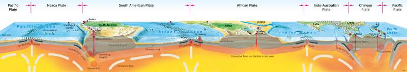
Cross section of the Earth’s crust
Plate tectonics
978-3-14-100890-6 | Page 14 | Ill. 3
Overview
The diagram shows a section through the Earth's crust and the uppermost part of the mantle in the Southern Hemisphere. In map 14.1, the section can be located based on prominent places (Lascar, Ol Doinyo Lengai and Kerinci volcanoes, Saint Helena Island). With the help of the processes in the lithosphere and asthenosphere visible in the section, plate tectonic processes as well as volcanism and earthquakes can be explained.
Continental drift
In the Mesozoic Era, the surface of the Earth consisted of the supercontinent Pangaea and the primordial Pacific Ocean. Since then, volcanism, earthquakes and trench formation have accompanied the breaking of the continents. These processes can currently be observed in East Africa.
Paleomagnetic measurements, paleontological findings and traces of the Late Paleozoic glaciations prove that the present-day positions of the continents are clearly different from earlier times. The German geophysicist and meteorologist Alfred Wegener had already put forward the hypothesis of continental drift at the beginning of the 20th century on the basis of the analogy of the course of the coasts framing the Atlantic. In the modern interpretation, plates move passively above the asthenosphere. According to this theory, the breaking and the drift of the continents are the result of dynamics emanating from the Earth's upper mantle.
Driving forces
The driving force of the plate movements are ascending, diverging or descending, converging convection flows in the asthenosphere. Along the plate margins, often intense mountain building, earthquakes and volcanism can be observed (see comment on 14.1). Mountains such as the Alps, the Himalayas, the Urals, the Appalachians or the Andes mark points of contact between two plates. Continental marginal mountains at active plate margins indicate ongoing subduction (Andes), while inner-continental mountains suggest a welding process in earlier epochs of Earth history (Urals). Submarine ridges - such as the Whale Ridge, the Guinea Threshold, the Sierra Leone Threshold and the Para Threshold in the Atlantic, the Hawaii Ridge and the Sala-y-Gomez Ridge in the Pacific or the Bengal Ridge in the Indian Ocean - are trajectories of hotspot volcanism
Ocean spreading and subduction
Six medium-sised or large tectonic plates are shown along the section (see 14.1). New oceanic crust is currently forming at three oceanic ridges - in the Atlantic, Indian and Pacific Oceans. There, magma is constantly pushing towards the seabed and spreads laterally. The further away the seafloor is from the crest region of the ridge, the older the crust is.
If new oceanic crust is constantly being formed in the crest region of the oceanic ridges and spreads laterally, then either the Earth would have to expand - for which there is no evidence - or the newly formed crustal portions would have to be compensated for by subducting oceanic crust elsewhere. This subduction occurs in deep-sea trenches that are located directly in front of the continents (in the image: off South America) or on the ocean side of curved island arcs (in the image: off Indonesia). There, the denser - and thus "heavier" - oceanic crust moves under the less dense - and thus "lighter" - continental crust. Island arcs are to be regarded as plate boundaries that do not run along continental margins, but "advanced" in the shelf area. They lead to the separation of marginal seas (e.g. South China Sea in illustration).
