
The World - Natural hazards and risk of natural disasters
Ecozones and natural hazards
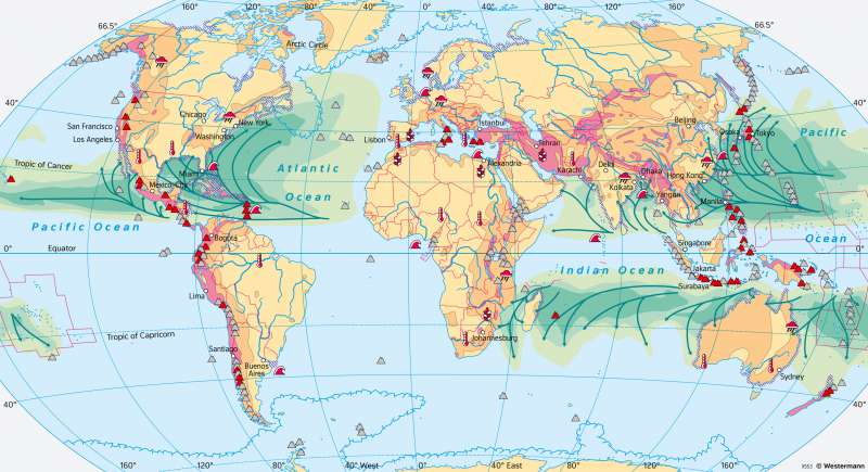
978-3-14-100890-6 | Page 23 | Ill. 3
Overview
Natural hazards are threats by natural phenomena, like tsunamis, hurricanes, earthquakes, forest fires, etc., which may cause damage and often cannot be predicted. When an area or location is vulnerable to an identified natural hazard, then it is exposed to a natural risk. For many natural risks, the expected financial losses can be roughly estimated.
Earthquakes
More than one million earthquakes are registered worldwide every year. However, they are not evenly distributed, but are mainly concentrated at the plate boundaries. The vast majority of earthquakes have tectonic causes and are associated with fractures, faults, and mountain building. When two plates rub against each other at their interface, they exert pressure on each other and become entangled, creating stresses. They are released as earthquakes when the resistance of the rocks to fracture is exceeded. Subsequent processes can be tsunamis, mudflows, and landslides.
Coastal flooding
During storm surges, an onshore storm causes exceptionally high water levels on shallow coasts, especially in bays and estuaries of large rivers. This often leads to severe flooding, as in 1962 in the area of the Elbe estuary. A particularly high risk exists on strongly indented coasts, where a storm surge can be intensified by the tides.
Climate Risks
Due to global climate change, average temperatures will increase worldwide by the end of the 21st century, although to different degrees in different regions of the world. In large parts of the tropical-subtropical dry regions, precipitation is expected to continue to decrease, while in the central and polar regions it will tend to increase. In addition, a greater energy contrast between the equator and polar regions will contribute to increased circulation and the formation of dynamic low-pressure areas. These will be accompanied by a meridionalisation of weather patterns, which will favour extreme weather phenomena such as periods of drought and heat, floods, and storms, especially in the Mid-Latitudes.
Sea-level rise will first affect the island states in the Pacific and Indian Oceans, whose territories are only slightly above sea level, but also states like the Netherlands, which are partially below sea level.
Tropical cyclones
Every year there are 30 to 100 tropical cyclones worldwide. They are called hurricanes in the Caribbean, typhoons in Indonesia and Willy Willies around Australia. Tropical cyclones can only develop above seas with high water temperatures (26 to 28°C). The warm, moist and thus unstable air masses above rise in the area of influence of the Intertropical Convergence Zone (ITCZ) and form powerful cloud towers, so-called cloud clusters. Cold air masses advancing from the north over the warm tropical sea areas can intensify this process. The energy released during the condensation of the rising air packets gives the air additional buoyancy and is the actual driving source of the characteristic vortex formation. The incipient rotation of the air masses allows a tropical cyclone to form. Easterly waves, small low-pressure vortices that form, for example, under the eastern tropical high-altitude current of the African Easterly Jet, set the rising cloud masses into a circulatory motion that is maintained by the Coriolis effect.
In contrast, tornadoes are much smaller in scale. They form in summer and occur most frequently in the Midwest of the USA.
Volcanic Eruptions
More than 75 per cent of volcanic activity is concentrated in the circumpacific "Ring of Fire". There, a chain of active volcanoes is arranged parallel to the deep-sea trenches. While effusive volcanism (for example on Hawaii) rarely causes major disasters, places with explosive volcanism (for example at Vesuvius) are at high risk.
