
The Americas - Hurricane Katrina
Climate
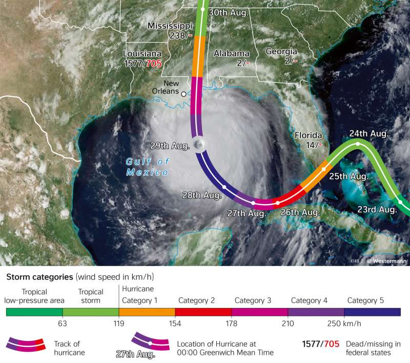
978-3-14-100890-6 | Page 173 | Ill. 4
Overview
The storm of the century is considered one of the most devastating natural disasters in US history. It caused large damage, particularly in the states of Louisiana and Mississippi, but also in Alabama, Georgia, and Florida. Around 1800 people were killed, hundreds of thousands lost their homes, and in New Orleans alone, more than three quarters of the city were flooded. The damage amounted to around 125 billion US dollars.
Development of Hurricane Katrina
Hurricane Katrina developed from a low-pressure vortex over the Bahamas on 23 August 2005. On 25 August, it reached the southern tip of Florida with average wind speeds of up to 130 km/h. Over land, the hurricane weakened somewhat and turned southwest. Katrina then moved over the Gulf of Mexico, where it again gained a lot of energy from the around 30° C warm water and rapidly increased in strength. On 27 August, the hurricane reached Category 3 of the Saffir-Simpson Hurricane Scale with means wind speeds of up to 185 km/h (see map 173.5). It veered more to the northwest. On 28 August, it strengthened again and reached the highest Category 5, with means wind speeds of up to 280 km/h. On 29 August, the hurricane turned to the northwest. On 29 August, the hurricane turned further north and hit the southern coast of the USA. By the time it reached New Orleans, Louisiana, Katrina had weakened back to Category 3. Over land, the hurricane rapidly lost energy, becoming a tropical storm over the US state of Mississippi.
